Day Eight
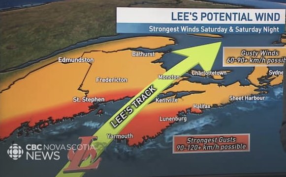
/Another long post, but (as you’ll read about later) I’m hunkering down in Edmonston, Canada, waiting for Hurricane Lee to finish battering the coastline and wrecking the weather all across Maine and Southeastern Canada. So … I have a little time on my hands… Enjoy!
Houlton to Presque Isle
With the rain relenting from one storm, I was now growing aware of the steady Northern march of Hurricane Lee. But the one constant of all the weather forecasts was their variability and mutability: it was kind of anyone’s guess what Lee was up to. I certainly wasn’t going to wait around to find out, and with the skies clearing I could make my own Northern push and see how much of the hurricane I could outrun.
Rolling along, I was now heading into Northern Maine which presents very different geography and culture. The horizon grew as the yards lengthened into potato & kale farms, places where the vegetables are all about as durable as the people who grow them. It’s a tradition up here that kids in school often get a week or two off to help with the potato harvest; and not just from their own farm, but also from neighbors’ farms as well. There’s pay involved, apparently, but it’s not the main driver of the custom. It’s a part of the culture up here. I rode past acres and acres of fields, many of which, brown and loamy, seemed like they’d either been harvested already or had been left fallow for the season. Don’t ask this city boy what crops were there, although I didn’t notice the purple potato blossoms I’d been told to look out for (the state flower of Maine, apparently). But I did see plenty of acreage of thick, dark green kale, as well as signs for “new potatoes” for sale by the side of the road, which made me smile. I wouldn’t think of “new” as a way to describe a vegetable (“new carrots,” “new eggplant”) … but then again, I can’t say that “fresh” potatoes would be a particularly common description for a potato, either. So on balance, ‘new’ seems like a perfectly appropriate description for what I’m assuming is a ‘recently harvested’ potato.
These are the kind of thoughts which one may find oneself entertaining, while cycling radio-free through the wide-open fields of Northern Maine. This one, at least. Judge me not.
And I’d planned a good route to get to Presque Isle from Houlton. Not that there are a lot of options. the whole left side of the state is logging. Private land, though accessible by cars. But off-limits to bikes. Collaborating on my route with Erik daSilva of Bicycle Coalition of Maine, I kept sending him route options that had me turning West and heading into Québec. “Yeah, you can’t do that,” was always his response. There were clearly marked (if unpaved) roads all through there, but apparently the North Maine Woods is a hyooooge tract of land that’s privately held by various logging companies. Any cyclist that dared head down one of those roads would be playing chicken with multi-ton logging trucks thuddering (simultaneously thundering and shuddering) down single-laned roads with walls of straight, tall pines on either sides and not a hint of a shoulder. It wasn’t apparent from the maps I was seeing online, so Erik finally sent me a map that clearly delineated “thou shalt not pass” territory for bikes. It was like looking at the lands Haunted Forest, North of the wall in Game of Thrones, somewhere I might just find John Snow fending me off with a white wolf.
Soooo, hence my reasons for heading east out of Baxter State Park. And now I was free to go North, but there are really only a few main county roads. They’re not bad biking, really - they have wide shoulders and I felt perfectly safe, even with some of the heavier industrial traffic that moves along US Route 1. It’s just a drag when you’re having your bucolic pedaling interrupted by the roar and wind of a cement truck or semi pounding down the road to your left.
However, if you look at the maps, there are many places where you can jump off the main route and take a county or residential road that runs parallel to US 1 for a few miles. You take that for a bit, get back on 1 for a mile or two, then jockey over to another such road for several more miles. These are roads that go past farms, farm equipment shops, farm supply shops, tack stores, convenience stores, and slightly wider parts of the road with gravel turnoffs just adjacent which purport to be towns, although some are identifiable as such only by a post office or a building with an official sign of some sort. I passed by one structure that was barely larger than a shed you might order at Home Depot and have delivered to your property, somewhere to store your riding lawn mower and ATV. Maybe some cord wood or feed for the goats. Then I saw the sign out front: “Town of Blaine, Inc.” Population 667, as of the 2020 census. Go Blaine High Bengals.
This whole latticework of side roads was great bike-touring land: wide vistas, roads that didn’t even bother to paint a line down the middle, because why? What traffic is there to divide? And a chance to see, at 15 mph, the homes, lives, and livelihoods of people living up here in “The County.” Which, by the way, is the Mainer’s way to refer to Aroostook County. There are many counties in Maine, and several unincorporated townships and rural areas, but there’s one big county to the North that sits like a Yeti at the top of the mountain: Aroostook. “I’m goin’ up county.” “You from the county?” “Down east is one kind of weather, but the County’s a whole diff’rent story.” The meaning is always understood.
In the town of Bridgewater I clocked a piece of something I’d read about but forgotten. A planetary model stood high on a mounted pole with a plaque below. “Uranus,” with a web address for mainesolarsystem.com and a QR code. Billed as (what I certainly don’t question) “the largest 3-D scale model of the solar system in the western hemisphere,” it’s a series of planetary renderings all in scale - both in size and proximity/distance to each other - of the planets in our solar system that we all learned about back when our Very Energetic Mothers had Just Served Us Nine Pizzas (hence Pluto is included…) I’d missed the first two because I was busy taking side roads, but in Bridgewater there I was, staring up at Uranus. (Cue all nine-year-old sniggers here. Mine chief among them.) I also caught Saturn in Westfield, right after I had ridden through the town of Mars Hill - a town in which I really hope Stephen King sets one of his more sci-fi novels, because … obsvee. The models continue for 100 miles, all the way up to Presque Isle, with the Sun being located somewhere on the University of Maine, Presque Isle campus.
I didn’t get to that, though, because I was more interested in some of the byways. I’d also been compiling a mental list of all the things I needed to attend to at the next proper bike shop I could find. Check tire pressure, new battery for my pressure gauge, some chain lube for wetter conditions, a changing cable for my Garmin, etc. And up ahead in Presque Isle was Bike, Board, & Ski - the best (and only) proper bike shop in Northern Maine. I’d reached out to BBS months ago, for insight into route options and trail conditions, and I’d been referred to them by a rep from Bike Coalition of Maine as a reliable resource with local, on-the-ground knowledge. So as I pedaled on, I ran through the checklist in my head, so as not to forget anything.
Part of my route into PI was along the Bangor-Aroostook Trail, a dirt & gravel route I’d initially looked into but had been shied from at first because (apparently) some cyclists had complained about there being a lot of dust on the trail kicked up from ATVs. So I figured I’d try this stretch, for the last 10-15 miles into PI, to see if I agreed.
I didn’t. At all. Granted, I was riding mid-week, after Labor Day, and after there had been some wetter conditions. But I had no dust, no ATVs, no encounters at all, in fact. And maybe that’s the thing - when you ride the trail could be a crucial factor. I had, apparently, picked the perfect time.
Also, the Bangor-Aroostook is a converted rail-bed trail, maintained by the state. Some of the ATV trails I’d ridden mid-state, by Mt. Chase, felt like wartime routes frequented by nothing but jeeps - but I learned that there are state-maintained routes and club-maintained routes. The clubs I refer to are ATV and snowmobiling clubs who make it their own business to maintain (or let crumble) the various routes. The clubs are MANY up here, and some want their routes rough and difficult to pass; that’s the fun of them. Others are laissez-faire about it. Yet others are more conscientious about grooming their trails. State-maintained trails, however, are held to a greater standard of accessibility, with more reliable grooming. Plus, they’re often built on old railbeds, so they’re typically less hilly and originated, at least, from more even, less rugged terrain.
Instead of the trials I’d had back West, this route was a breeze. There were still potholes to avoid, rough terrain I wouldn’t want to ride on a road bike, but with vistas, long stretches of simple, smooth, unpaved ground, and the unalloyed silence of solitary, backcountry riding.
When I got to Presque Isle, I went straight to BBS. And what a great experience. Noah, the tech, knew all about exactly every issue I wanted to ask. He also had terrific recommendations for local craft beers (which they sell in the shop - who doesn’t love a bike shop that considers beer a standard bike accessory?) Melissa, who was restocking apparel, discussed the Northern Maine culture with me and shared some recommendations for restaurants along my route as well as where to get a good whoopie pie - a Maine-specific treat that’s kind of a circular, brownie-cake sandwich with a particular kind of thick cream filling inside that’s wet and packed just like the snow that every skiier hates. And after I’d spent a good hour and a half at the store (solitary trail life had left me a bit wanting for conversation it seems) Mike, the manager (and I think owner?) of the shop personally walked me and Melissa to Governor’s restaurant for a quintessential, authentic, full-calorie whoopie pie which he paid for himself. Because that’s what Maine hospitality is like. Or at least in Presque Isle.
So, beer-ed and sugar-ed, with all the tech seen to that I needed, and with a new Bike, Board & Ski t-shirt I’ll proudly wear down to the threads, I headed the few miles on to the home of the Warmshowers host (Chris) who’d offered me a place for the night.
Now, I’ve mentioned a friend of Maine origin who’d given me specific tasks for my journey, not the least of which was having an authentic whoopie pie. That friend is John Cariani, the Presque Isle-born actor & playwright, whose ALMOST, MAINE I’d helped premiere of off-Broadway in NYC back in 2005. (John gamely did a Zoom quiz for my fundraiser that you can see HERE.)
It turned out that the Warmshowers host was a high school classmate of John’s and had, in fact, had breakfast with him the last time he’d come home to visit, a year ago! I asked Chris and his wife Denise to help me finish this ginormous whoopie pie for dessert (after we had the white chicken chili that Denise had made), and we took a selfie and sent it to John, without comment.
John being John, of course, he immediately recognized Chris and Denise … and the whoopie pie. “Hey, Governor’s! A Maine landmark…” he commented. But then, apparently, he recognized me. “Wait, is that Todd Cerveris?!?” John then texted me. “So glad you met Chris and Denise! Great people!” “I didn’t just meet them,” I replied, “I stayed at their place!” Somewhere in the Bronx, where John Cariani lives, there was doubtless a guffaw as the world shrunk instantly.
The wide open fields North of Houlton…
… every ride has to have at least one nine-year-old giggle in it …
… the Bangor-Aroostook Rail Trail
… imagine being on a train back in the day, wending your way through this landscape.
It took three people to finish one whoopie pie.


